[This story describes the decade-long struggle to obtain permission to clean up a small urban watershed. Cayman Chemical purchased the property including a small stretch of Mallet’s Creek in 1997. Applications to clean up the degraded stream were first submitted in 2001. Final approvals from all regulatory entities was never received. Clean up was initiated anyway in 2014.]
Public institutions, many of them with specific missions to preserve nature, are the biggest impediment to conservation in suburban America. Together with other governmental agencies with no conservation mandate, they effectively prevent any meaningful remediation unless you are willing to wade through their red tape for dozens of years.
Mallet’s Creek is an urban waterway that originates in a marsh near the Ann Arbor airport, winds its way for a few miles through the southeastern part of the city, and then empties into the Huron River. Concrete walls and limestone rip-rap dominate much of the stream bank, and the invasive, European strain of Phragmites australis chokes the rest of it. In heavy rainstorms, its flow increases more than one hundred fold as the runoff from many acres of adjacent parking lots and flat roofs suddenly pours in. In the winter, its salinity surpasses that of the Great Salt Lake as concentrated brine seeps into it from heavily salted roadways. This event sterilizes the creek of all living organisms below the waterline.

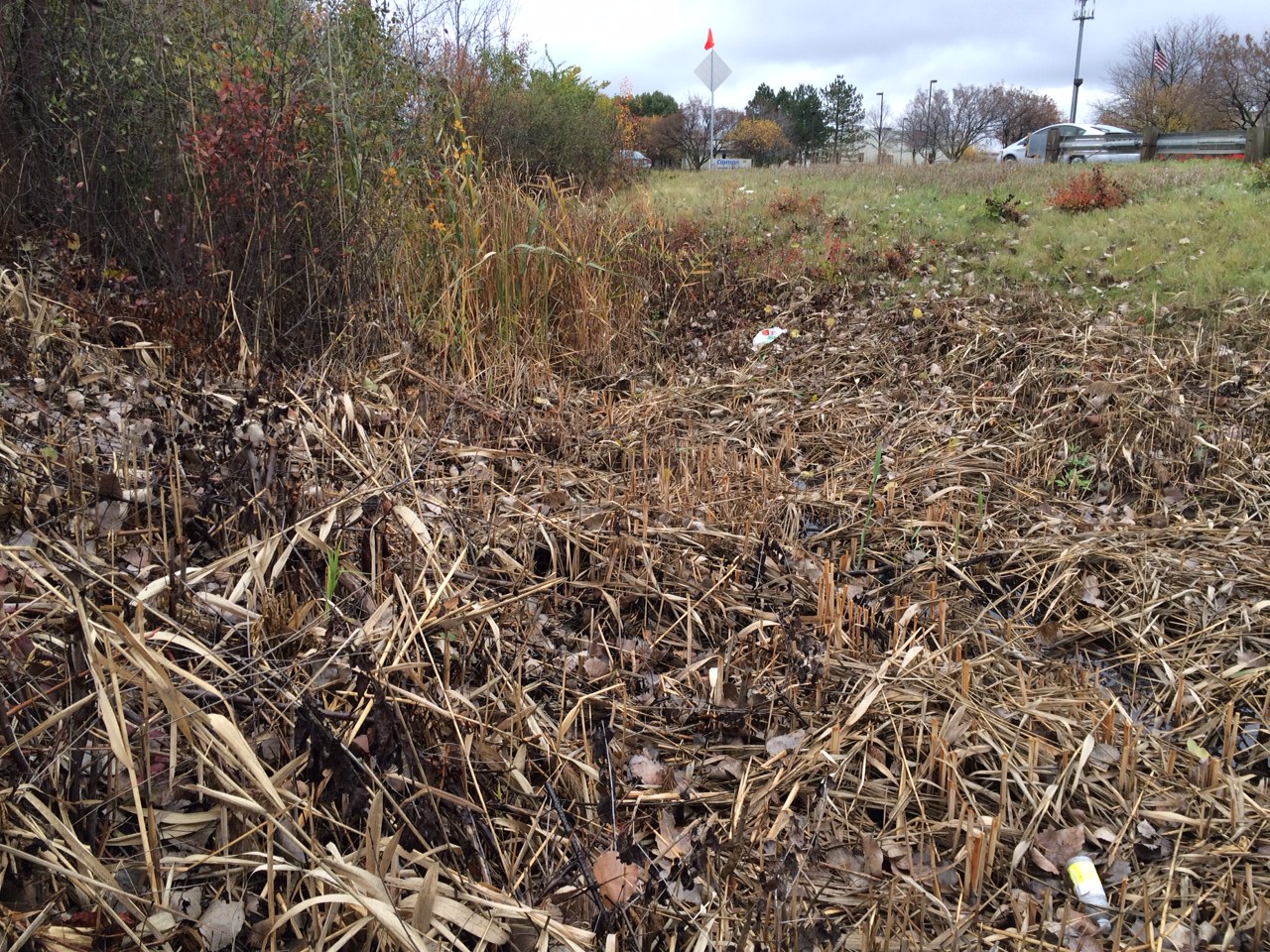
Mallet’s Creek before reclamation efforts


Mallet’s Creek after reclamation efforts
The stream emerges from a concrete pipe and flows for 87 feet across the campus of Cayman Chemical in Pittsfield Township, exiting into another pipe under Ellsworth Road as it enters into the City of Ann Arbor. When my company bought the property in 1997, the creek was a sludge-filled dead zone of decaying plant material and roadside trash. Its fate was mediated by the conflicting authorities of the Pittsfield Township Zoning Authority, the Washtenaw Country Road Commission, the Washtenaw County Drain Commission, the Michigan Department of Natural Resources, the City of Ann Arbor, and the US Environmental Protection Agency. In 2001, we began the application process required in order to enter into this “wetland” to remediate its degradation. We started the work three weeks ago, and we finished it yesterday.


Our reclamation project was sharply constrained by the unusual ecology of this waterway. We had to plan for flow conditions of essentially zero for several months at a time, increasing to more than two cubic meters per second in three to four annual flooding events. The mid-winter brine catastrophe had to be contained within the smallest possible volume at the bottom of the stream bed and refugia for plants and invertebrates created so that the lifeless bottom could be quickly re-colonized in the spring.
Our vision was to recreate, in this short section of creek, an ecosystem more reflective of the pre-human conditions about 10,000 years ago, at the end of the last glaciation. The overall flat and anaerobic bottom profile was re-sculptured into a narrow V-shape. This was lined with a mixture of rocks and boulders taken from local glacial moraines now mined as gravel pits. The sand and gravel was layered over the underlying muck providing a well drained, but relatively nutrient poor substrate for native plants. Some of the larger boulders weighing between five to seven tons were placed by heavy equipment, in a random pattern typical of glacial erratics.


The Black Curtain of Death (BCD) that we erected for a few days to mollify one of the local authorities. See additional post.
To address the winter die off and spring re-population, we created a refuge wetland running to the east along Varsity Drive. A dam of boulders about 18” high creates a lip that prevents the road brine from backing up into this side channel, which is spanned by a pre-stressed monolith concrete bridge to accommodate the sidewalk.

This refuge wetland extends more than 200 yards along the road, where it reaches a deep, permanent fresh water pond. The entire watershed for this pond consists of the lawn and sidewalks of Cayman’s main 1180 research building. That is important, because by instituting a minimal salting policy on our own property, we can insure that this body of water retains a normal pH and conductivity throughout the winter. Each spring, we can flood both the refuge wetland and our newly reclaimed creek with fresh water, arthropods, and all of the normal inhabitants that have not survived the harsh roadside conditions.
Over the course of the next 12 months, we will steadily re-introduce native plants, while we monitor for the inevitable return of Phragmites. A big bottle of Roundup is an essential when the creek in both directions is a monoculture of this invasive reed. Active management is the keyword when working to maintain a diverse ecology in these difficult circumstances.
Conservation boils down to an issue of trust. When we entrust conservation to a single public entity, like the National Park Service, it works in many cases because there is only one executive agent at the table. The Park Service has numerous failings, as I outlined here in my book, but in general they have kept large tracts of public land in a relatively clean and unspoiled condition. When multiple public entities claim jurisdiction of increasingly small tracts of land, as was true in this case, the result is complete paralysis and degeneration of the resource to its worst possible condition. A monoculture of invasives is tolerated as the status quo. Road salting, which has never had and would never pass an environmental impact study, is allowed to kill off entire ecosystems wholesale. Completely failed and ineffective practices (please see “Rant”) continue for years because they give a theatre effect of seeming to do something.
Private citizens and corporations like Cayman should be likewise entrusted to be the single entity empowered to improve their own “sensitive” environmental properties. When only remediation without concurrent development is proposed, all of the red tape and regulations we waded through should simply be waived, and each public body claiming jurisdiction reduced to the equivalent of cc status on an email. They should be copied on the work plans as they progress, but should be rendered powerless to obstruct them until the work is complete. At that time, they can either sign off and approve the remediation as completed, ask to have further improvements made, or file a lawsuit if they feel there has been gross misconduct and unlawful activity.

What did all this cost?
I will close with a photo of Mallett’s Creek where it emerges from our project and courses into Ann Arbor. There’s still a lot left to be done. L3 Communications is the next good steward of the land in line. This photo speaks for itself.
As Mallet’s Creek Continues…
